A Chinese junk in the Great Dismal Swamp – GM Memo 13th March 2006
The 1418 map leads us to a Chinese Colony in Virginia and North Carolina.
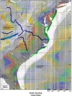
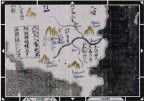
The 1418 map shows two river systems on the Atlantic coast of North America. The most Northern, opposite Greenland is clearly the St. Lawrence Seaway but what is the Southern, which is only about one third of the way up from the Caribbean? This river system is on the Northern part of a protruding promontory – in the same position with the same shape lies Cape Hatteras. Leading inwards from Cape Hatteras is the Roanoke forking just to the southwest then to the northwest as shown on the 1418 map. The 1418 map shows this river branching into 3 arms – the NW arm is in the same position as the New River (which becomes the Scioto) the SW arm is initially the New River then the Tennessee; the SE arm is the Yadkut. This is corroborated by the mountains shown on the 1418 map; travelling anti clockwise to the North the Blue Ridge, then the Cumberland Plateau to the west, to the southwest the Appalachians and in the south the Piedmont Plateau. The only mistake the cartographer has made is to show the branches of the river joining near Roanoke when in fact they all rise in the Appalachians to the west of Roanoke.
Jerry Warsing’s research
Ten years ago Jerry Warsing started research on the Ming Ho people who originally came from Virginia and North Carolina. They migrated westwards to the Appalachians. Jerry found they had a high incidence of Machado Joseph disease. Investigating the origins of this disease lead Jerry to Yunnan. With limited funds, Jerry was able to carry out a little DNA research and found that some Ming Ho people had a high admixture of East Asia genes. Although the samples were too small to be statistically significant, it set Jerry thinking whether there might be truth in the Ming Ho claim that they were not Indian people, but the descendents of shipwrecked sailors.
After several years of research, by 2002 Jerry was convinced that a fleet of some 200 ships under the command of Zheng He had been wrecked in 1432 on the coast between Southport, North Carolina and Norfolk, Virginia. Due to the marshy inhospitable coast, they marched inland up the Cape Fear (Yadkut) and Roanoke rivers and settled in the western foothills of the Appalachian Mountains between Salem and Ashville. Some of them also settled enroute in West Virginia where they left a proliferation of stone buildings – two storey stone houses, weirs, barns, mills, fishponds, reservoirs and the like; stone buildings commented upon by Powhatan. They also left Chinese plants – Pallowaddy and rice, Chinese chickens and small apes.
The accounts of the first Europeans to reach the river area shown on the 1418 map.
The records of the Virginia Company of London (ed. Susan Myra Kingsbury Washington D.C. 1906-1935 vol 3 page 547-48) describes the journey of Lieutenant Marmaduke Parkinson Northwards from Jamestown towards the Polomac. They visited one of the king’s [Powhattan] houses where they saw a China box. Asking how the box came into the King’s possession … “made answer that it was sent him from a King that dwelt in the West over the great hills [the Appalachians] some tenne dayes journey whose country is near a great sea, hee having the boxe, from a people as he said that came hither in ships, that weare cloathes, crooked swords and somewhat like our men and were called Acamack-China:”
The local king then offers to lead Lt Parkinson’s group from when they currently are (near the seven rivers running into Chesapeake Bay – the Potomac, Rappannanock, N Anna, James, Lafayette, Lynnham and Elizabeth Rivers) 150 miles west to the ridge of hills running south and north (the Appalachians) where they will find the [Chinese] king.
“The discovery whenst will bring forth a most rich trade to Cathay, China, Japan and those other of the East Indies to the inestimable benefit of this kingdom….”
In summary, the first European accounts corroborate Jerry Warsing’s research (Jerry is not aware of this – I have lost contact with him).
The Great Dismal Swamp (when the 1418 map shows the river reaching the sea)
To the southwest of Norfolk and north of the Roanoke River lies the Great Dismal Swamp. There have been 3 separate sightings of a very old Chinese junk which lies in this swamp.
(1) George Washington and his friend Patrick Henry formed a company to drain the swamp so they could grow your commercial timber. They cut canals to drain the water and after doing so
“When one marsh was being drained, an ancient Chinese sailing ship was discovered. Sara [Jackson] said no one knows how it got there.
This is taken from the Merrill Reading Skilltext series. Charles E Merrill publishing Co. Columbus Ohio, 1970. ISBN 0-675-06757X.
The second occasion was in 1939 when the US Corps of Engineers purchased George Washington’s company so as to build a canal linking the Great Dismal Swamp and Norfolk with Albemarle Sound (where the Roanoke enters the sea). They found when clearing the waterway that the Chinese junk was an obstruction and cut away part of its hull to leave a navigable channel. The US Corps of Army Engineers records do not say which waterway was being cleared nor give the position of the junk.
The third occasion was in 1943 when a fighter bomber took off from Norfolk Naval Base but developed engine trouble and crash landed in the swamp. The US Navy searched for the wreck and in doing so came across the junk (this is from a family member of the navigator of the bomber who emailed us).
Search for this junk
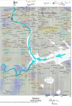
The runway from the northern naval base is aligned 050/230. We therefore searched the Great Dismal Swamp along the line 230 from the runway, especially where is crossed channels. WE found 21 wrecks but none appeared to be Chinese although some were very old.
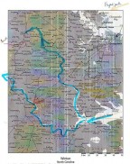
The 1418 map leaves me in no doubt that the river shown is the Roanoke and therefore that Zheng He’s junk sailed up it from Albemarle Sound. Some twenty miles from the sea the Roanoke splits in two, the larger stream branching off due north – it is named the Nottoway River. This river skirts the western edge of the Great Dismal Swamp. About 120 miles up this river near the town of Jarrat a bridge spans the Nottoway.
A friend of the 1418 website Richard Perkins was brought up here beside the bridge on the River Nottoway at Jarrat. He says
“The place where I was raised was the uppermost navigable limits of the Nottoway River… There has always been a story told around here that when the first white settlers (explorers came through the area they met ‘white’ people who were unknown to the English settlement in Jamestown and that these people were living in an established settlement in stone houses… I do remember seeing the foundation walls…Also I know of several locals who were in possession of blue and white porcelain fragments which were found in this area as well as one person who many years ago found a strange sword buried in the field for hiding. I have seen this sword once… it was dark coloured but not rusted as one would have expected.”
So I think we can say Chinese junks could have sailed up the River Nottoway past the western edge of the Great Dismal Swamp where one was wrecked on a bearing 230 from Norfolk Airbase – (i.e. the flight was airborne for around 7 minutes before engine trouble forced it down). So we should be looking in the River Nottoway near Winton around 36° 30’N, 77 00 west, for both the junk and the crashed bomber.
Summary
The 1418 map; finding the Emperor’s power of attorney; Jerry Warsing’s research; the accounts of the first Europeans to reach the area; the wrecked junk in the Great Dismal Swamp and the finds upstream on the Nottoway River all corroborate each other.
My proposal now is to find the junk in the Great Dismal Swamp with the help of television. It would make an entertaining afternoon tourists excursion being about 120 miles from Washington DC!
To view maps relating to this memo please click on the following:
Modern day map shoeing Roanoke

Modern day map showing Great Dismal Swamp and trajectory of plane

Modern day map of Great Dismal Swamp showing possible route of junk

Gavin Menzies
London
13 March 2006
View map – Click here to view the Zheng He’s integrated map of the world, 1418 map


